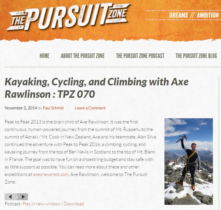
Category Archives: Peak to Peak 2013

Latest news from Axe

Greetings folks,

Its been a very busy time here at AxeonEverest HQ.  I wanted to share with you a quick round-up of the latest news.

Pre-order funding campaign target reached for my book ‘From Peak to Peak’

Yes that’s right! $5000 was the target for me to reach in the pre-order book sales campaign for ‘From Peak to Peak’.  For those of you who are wondering what pre-orders are, here is a brief explanation.

The world of book publishing has and is going through a major transition.  In the ‘old days’ to publish a book, one needed to write a manuscript then approach book publishers to try to ‘ink a publishing deal’.  The overworked and underpaid book publishers would plough through the hundreds of manuscripts, trying to select those few they thought were the most appealing and marketable (i.e. not necessarily the best book!).  Once selected they would sign a deal with the author to publish their book.  This deal would normally include editing, cover design, proof-reading, formatting, printing and finally distribution to major book stores.  In exchange for this, the lucky book author who managed to get his or her manuscript selected, would receive around 20% of the proceeds of the sales of each book. That’s right – a measly 20% (maybe a bit less or a bit more depending on the deal).  Definitely not a get rich quick scheme.  More importantly the author generally would lose COPYRIGHT to the book.  So the author no longer even owned his own work!

These days, with the introduction of e-books (electronic books), authors can write a book and publish it on websites like AMAZON completely for free. (Of course they need to design, edit and format it themselves which many people are happy to do).  Over 30% of all book sales in the United States recently are through e-books and the number is rapidly growing. Unfortunately this has seen traditional book stores in towns and cities closing down and going out of business. People these days do not need a hard copy of a book.  They do not need to visit a book store or purchase through the post and pay for expensive shipping costs.  They can order on-line and receive an e-copy instantly which they can read on their electronic devices like Kindle’s or iPAD.

I wanted the best of both world’s – hard copies of my book as well as e-book versions.  Many of my readers are not yet in the e-book era.  I also needed hard copies to sell during my keynote talk’s.  I did not have the patience or the desire to go down the traditional publishing route to ink a deal and hand over the copyright to receive a mere 20% on the sales.  So I opted to pay a publisher in Singapore to publish my book.  To off-set the costs of the publishing, I launched a pre-orders campaign through a website called PUBISHIZER.  This on-line platform allowed me to sell over the internet, copies of my book before it has even been printed.  The catch is when using the PUBLISHIZER platform, I had to enter a specific target amount, within a certain time frame to reach.  That was $5000 in 30 days.  If I did not reach that goal, then all purchases would be automatically refunded.  This proved a great way of giving me focus!

So the target is reached and I would like to thank each and every one of you who ordered the book.

For those of you HAVE NOT YET ORDERED! You still have 4 days left to order – after which time if you want to purchase you will need to visit a bookstore in Singapore to buy a copy.

To purchase please go to this weblink  https://publishizer.com/from-peak-to-peak/

It’s very simple – you can order an e-book or hard copy versions from here.  If you live outside Singapore I will even post them to you by airmail if you choose the shipping option. The pre-orders campaign ENDS on 13 November so sign up now!

‘From Peak to Peak’ will be delivered tomorrow

Tomorrow the 10 November is a very exciting day as ‘From Peak to Peak’ rolls off the press and is delivered to my house.  I am very excited to receive the first copies of the books and start distributing them to those lovely people who have ordered them.

'From Peak to Peak' - my book about our journey from Ruapehu to Aoraki/ Mt Cook

‘From Peak to Peak’ – my book about our journey from Ruapehu to Aoraki/ Mt Cook

‘From Peak to Peak’ interview on The Pursuit Zone

I had an interesting interview about our ‘Peak to Peak’ expedition’s recently on an American website called ‘The Pursuit Zone‘.  This website interviews adventurers who ‘dream big, get out of their comfort zones, and accomplish ambitious pursuits.’

They record the interviews and publish them as PODCASTs.  A PODCAST is basically a sound recording which you can listen to over the internet.  My interview can be listened to from the comfort of your own computer by clicking this link here.  If you have some time go to the website and check it out – they have some really interesting interviews with people who have done all sorts of inspiring, adventurous and cool things.

Click the image to hear a POCAST interview about our Peak to Peak adventure on THE PURSUIT ZONE.

Click the image to hear a PODCAST interview about our Peak to Peak adventure on THE PURSUIT ZONE.

People who inspire me

Starting shortly I am introducing a new section to my website titled ‘People who Inspire Me’.  Here I conduct short interviews with special people who are doing inspiring things.  Not inspiring in terms of making billions of dollars from raping the planet and the earth’s resources, or undertaking activities that burn copious amounts of fossil fuels.  But tales from people who get out and make positive impacts, who send positive messages through the way they live their lives.  We all have a part to play in the future of our planet.  I am very excited to share these stories with you and if at least one of them can touch and inspire you to make positive changes then I will be very happy 🙂

That’s all for now folks, enjoy the rest of the weekend!

Lots of Love,

Axe

What makes a great Christmas present and only costs 25 dollars?

The answer to this riddle is a copy of my new book ‘From Peak to Peak’!

I launched a pre-orders campaign 7 days ago and am very proud to say we have sold 150 copies already and are 60% towards the funding target of $5000 in pre-orders!

Thank you so much to those people who ordered already.

For those of you who have not ordered yet then please visit the link below to place your orders online.  If you live in Singapore I will deliver for free. If you live outside Singapore – simply choose the shipping option and I will send the books to your postal address by email. Every book ordered through the pre-orders will be AUTOGRAPHED by me!

Order by clicking this LINK:  https://publishizer.com/from-peak-to-peak/

There are options to buy:

–  an ebook ($10)

–  a single paperback copy ($25)

–  a double paperback bundle ($50)

–  a triple paperback bundle ($75)

–  Five pack bundle ($100) – a saving of $5/book!

As a teaser – I have included below a sample of Chapter 4 – Pit of Exploding Fire

With my very patient and supportive publisher Mr Phoon Hwa after the radio interview for my new book 'From Peak to Peak'

With my very patient and supportive publisher Mr Phoon Hwa after a radio interview this week on 93.8 LIVE for my new book ‘From Peak to Peak’

CHAPTER FOUR – PIT OF EXPLODING FIRE

DAY ONE

Ruapehu is Maori for ‘the pit of exploding fire’. Being an active volcano and the highest mountain in the North Island, it attracts a lot of visitors. During the winter months skiers carve up the slopes at the two commercial ski fields, Whakapapa and Turoa, and during the summer tourists, trekkers and climbers traverse the same slopes, revelling in the beautiful views.

Like any mountain, Ruapehu demands respect. Visitors can drive to an elevation of 1600m and continue on foot, and this ease of access can sometimes encourage ill-prepared and inexperienced climbers to venture where they shouldn’t. As a result, Ruapehu has claimed her fair share of lives over the years. What begins as a nice day walk in the sunshine can often end with a struggle to descend in whiteout conditions, strong winds, driving rain and snow.

During my winter climb of Ruapehu in 2011 with Jim, I had used plastic mountaineering boots with crampons and an ice axe. That climb had been on snow and ice all the way from lodge to summit. For our Peak to Peak attempt I made a fundamental mistake in assuming that in December, the Southern Hemisphere’s summer time, the snow would be limited to a smattering around the summit.

When Jim sent me a photo of the mountain two weeks before we left for NZ, I was in for a surprise. Ruapehu was still heavily plastered in snow, the white line starting only a few hundred metres above the lodge. What I’d envisaged as a simple scramble up rocky ground had now turned into a full-fledged snow and ice climb.

The problem was, Alan and I had sent all our mountaineering gear to Mt Cook Village in preparation for that mountain, which I knew was snow covered year-round. So I scrounged around to find an old pair of strap-on crampons in my storeroom, and I arranged for Jim to borrow ice axes from the Auckland Tramping Club. Jim would bring a spare set of crampons for Robert, and Alan opted to buy a simple pair of step-in crampons. These are used for walking on snow, as opposed to climbing, and have no front teeth to give purchase on steep ground. But for the moderately angled slopes of Ruapehu Alan thought step-in crampons would be okay.

Alan, Jim and I were confident using climbing gear on steep snow and icy ground. Robert however, had never held an ice axe in his life. In the weeks leading up to the trip he’d grown increasingly nervous, asking several times if I thought he’d be able to manage the climb, especially given he’d never worn crampons. With my usual exuberance I reminded him he’d been born and bred on a steep-sloped sheep farm, and that he’d probably find it an easy return to the days of his childhood. Except of course, that this time the ground would be covered in ice and he’d be wearing metal spikes on his feet…Anyway, I added flippantly, full instructions and training would be given and we’d have a rope for security, if needed.

On the official first day of Peak to Peak we rose at 5:30A.M. to a stunning morning. I had been sharing a room with my father, whose freight-train snore sent me crawling to a couch in the lounge area around midnight. But even if my ears were ringing, my hangover had passed, the storm had blown through and the sun shone brightly as Jim treated us to a sumptuous breakfast of sausages, bacon and eggs. I was full of hopeful anticipation of the day ahead.

We set-off at 7:30A.M. after an obligatory team photo. Our original plan had been for Alan, Jim, Robert, Dad and myself to make the one day climb, but Dad opted to wave us off and stay in the comfort of the lodge. I felt guilty leaving him behind after not having seen him for one year, and had been looking forward to sharing the experience with him. But even at the relatively low altitude of the lodge he had breathing difficulties, and owing to the amount of snow and ice up higher it was becoming clearer that this would not be the easy jaunt I’d first envisioned.

We plodded slowly up the rocky slopes of Whakapapa ski field. Alan and Jim were in front, chatting merrily away. I walked behind with Robert. My school friend had been training hard for the climb and over three months had lost 20kg. It was amazing to see him look and feel so good.

Unfortunately our conversation was cut short as I started having problems with my breathing. I suffer from asthma, though strangely enough, in the tropics and in Singapore it never affects me. As soon as I arrive in NZ and breathe the cold air, it returns. I had an old asthma inhaler with me which was about two years past its use-by-date. I puffed away on it, but it didn’t help much and the constriction would go on to plague me all day.

After one and a half hours climbing we hit the snowline and sat to don our crampons. I attached mine to my boots first, then helped Robert into his. He was nervous about wearing them and his first few steps were taken gingerly. “You only have to remember two things with crampons,” I explained, glancing nervously up the slope. “With each step, focus on stamping as many teeth into the snow as possible. Secondly, keep your feet well away from each other so you don’t trip over them. Easy right?”

Robert was not looking very confident, and I could tell from his voice that he was considering backing out. “You’ll be fine,” I reassured him, and to his immense credit (and possible gullibility) he took the words to heart and was soon quietly but steadily cramponing up the steep slope behind us.

After four hours we reached the crater rim, where we were met by strong gusts of icy wind. I had my warmest clothing on now, thermal layers, polar fleece wind breaker, and a shell jacket with gloves and hat. Regardless, it was uncomfortably cold whenever we stopped moving, the cold tearing through my layers to chill me to the bone.

As we climbed up to the rim I noticed Alan was having some problems with his in-step crampons. They were strapped to the bottom of his boots and appeared to be sliding and slipping off every couple of steps. He was forced to continuously stop and adjust them, which was slowing him down.

In the centre of Ruapehu’s caldera is a lake that never freezes, its heat generated by the volcanic activity beneath. When you climb from the Whakapapa side as we had, the actual summit of Ruapehu is on the opposite side of the crater rim. To reach the craggy point, named Tahurangi Peak, one must traverse right through the crater and around the crater lake, then up the steep crater wall onto the short summit ridge. Getting onto the summit ridge is the most difficult section of the climb, and involves 150m of exposed climbing. This is not difficult for a confident climber, but it’s still not a place you can afford to slip. I shot a furtive glance at Robert and forged onwards, praying that the snow would be firm enough for me to kick secure steps for him to follow.

As we crossed the crater we passed the Dome Shelter, a tiny hut offering shelter to climbers. In 2007, two climbers had been resting there overnight when the mountain erupted. One of the climbers was pinned in the hut by a boulder, and was incredibly lucky to make it out alive, suffering serious injuries that resulted in his leg having to be amputated.

Past the shelter we slowly made our way across the crater  and were soon climbing the steep wall on the opposite side. Here I took the lead and kicked steps up the steep slope. The snow was in great condition and I was very relieved to see that Robert could follow my steps confidently. Jim and Alan followed slowly behind.

At the top of the wall I was met with a short, 2m vertical section that allowed me to pull myself up to the rim. Popping over, I was hit by the full fury of the wind. We had been sheltered from the worst of it on our way up, but it was sub-zero and absolutely freezing.

Caught in its roar, there was no easy way to communicate, so I took a quick video and screamed into my camera, “Day one of Peak to Peak, and there’s the summit of Tahurangi.”  It was only 200m away horizontally, and around 100m above our heads. Robert came up into the wind followed by Alan and Jim, and we set-off for the most dangerous section of the climb—the exposed traverse onto the Skyline Ridge. Stepping onto it, I immediately noticed a change in the snow conditions. It was hard ice, exactly what I had been dreading. “Shit, shit shit…” I muttered to myself, thinking of Robert’s wife Denise and their two young boys.

At times I might have felt ill from the risk I placed upon myself, but being responsible for another person’s wellbeing compounded that anxiety tenfold. I had invited Robert on this climb, it had been my idea. When he’d asked me if he would be okay, he had put his faith in me, and I had told him that he would be looked after. Now, I was very concerned as to how he was going to cross 100m of this steep, exposed ice. Turoa ski field stretched far below us; it would be a very long fall if we made a mistake. And I knew I would never be able to live with myself. For the first time I regretted the decision to invite him.

“Okay, let’s rope up for this section!” I screamed into the wind. Jim had brought a rope and three climbing harnesses. I helped Rob into his harness and Jim and I also harnessed up. Alan tied a makeshift harness with a looped sling and then fastened himself to the back of the rope. I was absolutely freezing by the time we were ready to move again. The sky was clear, but this was not a nice day for climbing. I longed to get to the summit quickly and head back down, where I could begin to warm up again.

I stepped onto the bridge, the ice so hard that my boots and crampons could not even make an impression. Unable to kick any decent footsteps for Robert to follow, I resorted to cutting steps with my ice axe. This was slow going, the head bouncing off each impact, until I had cut my knuckles open and left a trail of bloody spots for the guys to follow. I decided to return deliberately and slowly, kicking tiny steps in the hope that the others could follow.

Robert seemed to be moving okay. He weighed around 90kg, and I clocked in at about 68kg. I prayed he did not slip and fall as I was unsure I could hold his weight if he did.

The rope was moving very slowly and I looked back to discover that Alan was having all sorts of problems. His small instep crampons were not suited to climbing the rock-hard ice, and he was having to cut each step with his axe. He later told me he nearly fell, twice. After 30 minutes of painstaking progress in the blistering wind, and nowhere near enough physical exertion to keep my body temperature up, my limbs felt like concrete.  “Hurry up guys…” I muttered as I stood stamping my feet and trying to get warm.

Metre by metre the rope inched up until finally I reached the summit, Tahurangi Peak, the highest point in the North Island. Robert soon joined me, followed by Jim and Alan a few minutes later. By this stage I had been standing in this incredibly exposed position for long enough to grow seriously concerned by how cold I was. My fingers were very painful and I knew from experience they were starting to get frost nipped.

I should have been elated to reach the summit, but I was not enjoying the experience and was secretly dreading the fact we had to climb down the same steep ice we’d just struggled up. Despite my gloomy outlook, I smiled in admiration of Alan for reaching the top. I would not have liked to climb those hard, icy slopes using tiny instep crampons. In fact out of all the climbers I knew, he was one of the only guys with enough skill and nerve to actually manage it.

It was one of the many reasons I loved adventuring with Alan. Time and time again he proved himself in difficult situations. And as it turned out, it was not the last time he would have to.

My camera froze and ceased to work seconds after I pulled it from the safety of my jacket, so there would be no summit video. But in many ways I was glad; I wanted to get off that damn mountain as quickly as possible. After a short rest we set off back down in the reverse order we had ascended.

“Slowly but surely Rob–make every step is secure before you put your weight down–slipping’s not an option here,” I yelled into the wind.

He squinted at me. “If I had known it would be like this, I never would have come.” There was no smile to soften the regret in this statement, and the roast chicken joke I’d been formulating froze upon my lips. It was probably for the best.

Slowly we retraced our steps. I felt for Alan, having to climb down the hard ice in his trekking shoes and instep crampons. It must have been a nerve wracking experience, but somehow he did it and soon we had popped back down the short, vertical wall to shelter and rest, out of the bluster.

For the first time in two hours I could relax and begin to warm my hands, as we congratulated each other and enjoyed some food and drinks in the sunshine. It was a gorgeous spot to have a break and sitting high above the crater lake we could the distant peaks of Tongariro, Ngauruhoe, and the dark blue waters of Lake Taupo.

Unfortunately, a volcanic rumbling was on its way. During our final traverse back down the crater wall I was overcome with an intense, and entirely unexpected, need to empty my bowels. It was one of those awful attacks that sweep through your entire body, and the cramping waves left me doubled over my axe and groaning. The ground was too steep to safely stop, a classic case of being stuck between a rock and a hard place.  I was also tied to three other men, who were slowly ambling down the mountain and quite unaware of the fact my digestive system was about to unload a WMD.

I finally got to a point where the slope eased off and untied myself, scuttling in an odd kind of crab walk towards a large rock jutting up from the snow. It was a touch and go moment. As I crouched down holding my pants in one hand, my body motions now well and truly beyond my control, my free hand went in search of a small roll of toilet paper from inside my pack. Fingers trembling I eventually found it, only to pull it out, fumble, and watch in horror as it bounced down the snow to rest about ten meters away. I crouched there in disbelief, staring at it, and willing it to defy gravity and roll back up to me. I waited. It did not move. I got angry, and then my bum alerted me to the fact that I would soon be getting frostbite in places no one should ever have to suffer. With a grunt of disbelief I accepted the inevitable and realised there was no option but to pull up my trousers and gingerly walk down the slope to retrieve it. Needless to say, the whole episode was extremely…unpleasant, and it took me some time (and almost a whole roll of toilet paper) to get myself into respectable shape again.

To make matters worse, the team had been sitting about fifty meters away watching the entire episode unfold, generously yelling all manner of helpful tips and advice, which only served to infuriate me more. As we set off back down the hill my grumpiness subsided, and I even managed a small grin. ‘Pit of exploding fire’, indeed.

At 5:30P.M. we arrived back at the lodge. It had taken us 10.5 hours to summit Ruapehu and return. Rob and I rested our sore feet, grateful to be back in civilisation. Alan and Jim stood out the front chatting away, as if they’d just returned from a stroll down the street for some milk.

That evening Robert called his wife Denise, who had been following our progress on the GPS SPOT Tracker in my backpack. This beamed our positions via satellite to a website which followers could view in real time, on a 3D map. When Denise saw the beacon go straight down the crater wall for fifty meters, she thought one of us had fallen off the mountain. Robert took great pleasure in enlightening her, but impersonating my crab walk over the phone proved almost impossible.

After the dicey summit, I was really relieved to see how Robert felt about his achievement. On the mountain he’d been wracked with doubt, at one point saying he wished he hadn’t come. However I could see he was extremely proud of himself, and deserved to be. He had trained hard for four months, lost a significant amount of weight, and achieved something he’d thought himself incapable of.

As we sat watching the sunset, he told me that only a few months earlier he’d had difficulties bending over to pick things up. Now, after his training program and weight loss his body had enjoyed a major overhaul. It had only been a 10.5 hour climb, but the positive effects on Robert’s life were profound. It was reaffirming, and reminded me why I love adventure and challenge as much as I do. Losing weight and maintaining fitness are one thing, but gaining confidence is one of the greatest gifts you can give yourself. Nothing of value in life can be obtained without some risk and effort, and that night I slept a happy man.

Favorite images from Peak to Peak 2013

Well as with all things in life – they come and they go.  At the end of the day all we have left are the memories.  Photo’s can be very nice to help preserve the nice times and I would like to share here our favourite images from Peak to Peak 2013. Thanks to Alan Silva and Tim Taylor also for contributing,

CLICK the above image to see an interactive map of our route on FOLLOWMYSPOT website!

CLICK the above image to see an interactive map of our route on FOLLOWMYSPOT website!


Robert Mills and Grant Rawlinson heading up the crater rim towards the summit of Tahurangi Peak, Mt Ruapehu

Robert Mills and Grant Rawlinson heading up the crater rim towards the summit of Tahurangi Peak, Mt Ruapehu. Photo Alan Silva

Grant Rawlinson, Jim Morrow and Robert Mills enjoy the view in the high winds from the summit of Tahurangi. Photo: Alan Silva

Grant Rawlinson, Jim Morrow and Robert Mills enjoy the view in the high winds from the summit of Tahurangi. Photo: Alan Silva

Grant Rawlinson, Jim Morrow and Robert Mills enjoy the view in the high winds from the summit of Tahurangi. Photo: Alan Silva

Grant Rawlinson, Jim Morrow and Robert Mills enjoy the view in the high winds from the summit of Tahurangi. Photo: Alan Silva

Alan Silva, Jim Morrow and Robert Mills descend the crater wall of Mt Ruapehu after reaching the summit.

Alan Silva, Jim Morrow and Robert Mills descend the crater wall of Mt Ruapehu after reaching the summit.

Alan Silva starting the cycle down the slopes of Mt Ruapehu towards Taumaranui.

Alan Silva starting the cycle down the slopes of Mt Ruapehu towards Taumaranui.

Grant Rawlinson starting the paddle in the 'Divorce Machine' inflatable kayak down the Whanganui River.

Grant Rawlinson starting the paddle in the ‘Divorce Machine’ inflatable kayak down the Whanganui River. Photo Alan Silva.

Kayakers on the banks of the Whanganui river.

Kayakers on the banks of the Whanganui river.

Campsite 'Poukaria' on the banks of the Whanganui river.

Campsite ‘Poukaria’ on the banks of the Whanganui river.

Canadian kayaks line the banks of the Whanganui river.

Canadian kayaks line the banks of the Whanganui river.

Grant Rawlinson paddles the final 20km stretch of the 245km  to Whanganui town.

Grant Rawlinson paddles the final 20km stretch of the 245km to Whanganui town.

Alan Silva and Grant Rawlinson enjoying the paddling in the rain.

Alan Silva and Grant Rawlinson enjoying the paddling in the rain.

Low could lines the banks of the Whanganui river as we paddle in the rain

Low cloud lines the banks of the Whanganui river as we paddle in the rain

Alan Silva and Grant Rawlinson in the middle of the Cook Strait.

Alan Silva and Grant Rawlinson in the middle of the Cook Strait. Photo Tim Taylor.

Tim Taylor approaching Arapawa Island after paddling the Cook Strait.

Tim Taylor approaching Arapawa Island after paddling the Cook Strait.

Grant Rawlinson takes a photo of the Tory Channel  entrance after paddling across the Cook Strait from Makara beach in Wellington.

Grant Rawlinson takes a photo of a ferry exiting the Tory Channel entrance after paddling across the Cook Strait from Makara beach in Wellington. Photo Tim Taylor.

A ferry enters the Tory channel as seen from Arapawa Island.

A ferry enters the Tory channel as seen from Arapawa Island.

Who is that in the paper?

Who is that in the paper?

Another day, another puncture on the ride south towards Mt Cook.

Another day, another puncture on the ride south towards Mt Cook. Photo Alan Silva.

Alan Silva getting wet during a rain storm on the cycle south.

Alan Silva getting wet during a rain storm on the cycle south.

Alan Silva enjoys a rest break on the cycle south.

Alan Silva enjoys a rest break on the cycle south.

Alan Silva cycles along the Kaikoura coastline.

Alan Silva cycles along the Kaikoura coastline.

Alan Silva cycles past Lake Tekapo.

Alan Silva cycles past Lake Tekapo.

Enjoying a rest break on the ride south.

Enjoying a rest break on the ride south.

Alan Silva climbs steep moraine above the Tasman Glacier on the way to Cinerama Col.

Alan Silva climbs steep moraine above the Tasman Glacier on the way to Cinerama Col.

Grant Rawlinson just visible on centre right about to cross under the Anzac peaks on avalanche and rock fall threatened slopes.

Grant Rawlinson just visible on centre right about to cross under the Anzac peaks on avalanche and rock fall threatened slopes. Photo Alan Silva.

Alan Silva climbs the summit ride on Aoraki/Mt Cook.

Alan Silva climbs the summit ride on Aoraki/Mt Cook.

Alan Silva climbs the summit rocks on Aoraki Mt Cook.

Alan Silva climbs the summit rocks on Aoraki Mt Cook.

Grant Rawlinson on the summit of Aoraki/Mt Cook.

Grant Rawlinson on the summit of Aoraki/Mt Cook. Photo Alan Silva.

Alan Silva enjoys his 7th time on the summit of Aoraki/Mt Cook.

Alan Silva enjoys his 7th time on the summit of Aoraki/Mt Cook.

Alan Silva descending the summit rocks on Aoraki/ Mt Cook.

Alan Silva descending the summit rocks on Aoraki/ Mt Cook.

Alan Silva descending through the crevasses on the Linda Glacier.

Alan Silva descending through the crevasses on the Linda Glacier.

Peak to Peak 2013 – the movie

I hope you enjoy this short movie of ‘Peak to Peak 2013’ as much as we did putting it together….

Peak to Peak is complete!

‎What an incredible feeling of relief and satisfaction it is to sit here in the safety of Mt Cook village and write this update over the final 5 days of Peak to Peak 2013.

We departed the small town of Twizel on day 18, loaded with food for 7 days in a big bag on the back of my bike.   After the Cook Strait crossing, I had called Mum who informed me very wisely to drink lots of water and have a nice meal with some vege’s to help recover.   Instead of listening to her,  I ate 6 oysters and 3 pints of beer, then proceeded to vomit it all back-up 2 hrs later. Once again it was a good lesson that we should always listen to our Mums. Learning from this incident and not wanting to incite her wrath this close the Christmas, (it could affect the quality of my xmas gift) we bought a carrot with us in our food supplies.

From Twizel it is a 60km ride to Mt Cook village.  The first 45km was beautiful. Riding around Lake Pukaki, with very little vehicle traffic and lovely weather.  Mt Cook appeared in a shy mood however and covered herself in a cloak of cloud. The last 15km into Mt Cook village turned into the hardest 15km of the entire cycling trip. A brutal headwind saw us battling away in low-low gear.  Averaging 7km per hour all the way to Unwin Lodge where we finally stopped for the night. I very gratefully flopped down in the shelter of Unwin lodge, grateful to be out of the wind.  I sat there in a daze as if someone had been repeatedly slapping me in the face with a wet fish. A good cup of tea later, I was all refreshed and we set about packing our climbing gear for the final phase of the journey, the climb of Mt Cook. During the evening the cloud lifted and New Zealand’s highest peak finally revealed herself, towering mightily 3000m+ above our heads. I was seriously daunted about the prospect of climbing Cook, my legs felt tired from the bike ride, and considering we were going to do the brutal walk-in all they up to Plateau Hut (most people fly this 1300m vertical section as it is dangerous and very tough work), I knew I was going to need to push very hard and have some luck with the weather to pull this one-off.

Day 19

We set-off at 9am after some early morning rain showers.  Our bikes were fully laden with packs, food for 5 days and climbing gear. We peddled slowly up the Tasman valley road for 10km, then off onto the old Ball Road. The old Ball Road is no longer a road, it is very rough and follows the moraine walls of the mighty Tasman glacier. It was hard work cycling up this, very bumpy and we alternate between riding where we could and doing a lot of walking and pushing. Eventually we could ride or push no further after about 7km. We disassembled the bikes and stashed them under a large rock, wrapped up in a small tarpaulin to stop the Keas (NZ mountain parrot) eating them. We then set-off on foot for a one hour slow plod to the tiny hut called Ball Shelter. My backpack felt heavy, my legs sore and I was hot and bothered as I wandered along in a bad mood. How was I going to carry all this gear up to Plateau Hut tomorrow feeling like this I thought to myself dejectedly? We soon arrived at Ball Shelter and I had a sleep and plenty of water, followed by a huge meal of pasta, tuna (and the carrot!).

Alan Silva cycling up the Tasman Valley Road with his climbing pack strapped to  the back of his bike.

Alan Silva cycling up the Tasman Valley Road with his climbing pack strapped to the back of his bike.

Day 20

‎The overnight rest and pasta meal seemed to work wonders and I felt refreshed when our alarms wake us at 3am. We cook porridge and tea in the hut, and set off at 4:10am, fully laden with climbing gear, sleeping and bivvy bags and food for 5 days. The night is beautiful and clear with great moonlight. By the light of our headtorches we make the steep scree scramble down to the Tasman Glacier, then the clumsy stumble on loose rock across to the moraine wall where we begin our climb up to Plateau Hut. We are choosing to climb to Plateau Hut via a route called Cinerama Col. Very few people these days climb up this route.  Although it is the shortest way to Plateau hut, it has a steep and nasty scree slope at the bottom half (getting worse over the years as the glacier recedes), then a trudge up the Boys and Ball glacier under some seriously dangerous rock fall and avalanche prone territory.  I was pretty nervous about the day ahead and adrenalin was pumping as we set-off up the steep scree slopes. We slowly worked our way up the scree, keeping a good horizontal distance between us as to not knock down rock on each other. We made good time and in a few hours had reached the snow at the foot of the Boys Glacier.

Alan Silva working his way up the steep loose scree slopes towards Cinerama Col.

Alan Silva working his way up the steep loose scree slopes towards Cinerama Col.

Here we stopped for a drink and a rest, then donned crampons and set-off on a slow plod all the way up the glacier. At the top of the Boys Glacier, we had to turn down the other side and cross under the Anzac peaks, which hover menacingly over the Ball Glacier. This is very dodgy, with lots of rock fall and avalanche debris everywhere. I nervously tried to move as fast as possible along under here, Alan being slightly heavier than me was punching through the snow up to his knees and making slower time.

Me crossing the top of the Boys Glacier and about to head down under the dangerous slopes under the Anzac Peaks, note the rock fall and Avalanche debri on the slopes.

I am just visible center right of photo crossing the top of the Boys Glacier and about to head down under the dangerous slopes under the Anzac Peaks, note the rock fall and Avalanche debri on the slopes. (Photo Alan Silva)

We were in crevasse territory now, so roped up then had a hard grunt up the final snow slopes to Cinerama Col.  We finally popped over the top to be treated with glorious views of the Grand Plateau after 10 hours. We sat and had lunch then continued for a 2 hour plod across the grand plateau to Plateau Hut. We arrived at Plateau Hut, rather and hot and sweaty, 11 hours after leaving Ball shelter.  I felt strong with plenty of energy – so it was a good positive sign I was in good shape for Cook.

Day 21

We slept at Plateau Hut overnight and the wind blew in huge gusts upto 110km per hour. I was worried at some points the hut may blow away. Lucky they build them strong, however day 21 saw the wind and rain driving in all day long.  We were confined to the hut for a compulsory day of rest which was not a bad thing as our bodies were in need of some recuperation. We listened anxiously to the weather forecast over the mountain radio schedule at 7PM that evening. The forecast for the next day was for mainly fine, 40km per hour winds, a freezing level of 2200m with cloud and rain coming in for the next day. It looked like tomorrow was our opportunity, and if we did not take it then we would be stuck here for days waiting for the next clearance.  We did  not have enough food to wait up for too many days.  We were both concerned with the amount of snow that had fallen during the day and did not feel the conditions were necessarily as good as we would have liked but knew we had to push this one if we were going to pull it off.  We prepared our gear that evening, ready for a very early departure and went to try to sleep at 9PM.

Day 22

We set our alarms for 12:00AM, however I did not need my alarm.  I was far to wired up to sleep at all and the adrenalin was flowing through me as I lay in my sleeping bag and went over and over my preparation plans to lave the hut.  At 11:45 I got up and did the first important task of the day – a visit to the toilet.  As I walked outside the hut I was very happy to note the wind had dropped right down, and the sky was completely clear.  I was treated to an amazing view of the milky way galaxy looking glorious above me, as the stars glistened and speckled.  It is truly magical and a special place to stand on the grand plateau by yourself in the middle of the night and just look and watch.

We cooked breakfast quickly and packed our gear.  We were both taking 1l of water each, and the stove incase we needed to melt more.  We took a few bars and some jet planes also to eat, then were off and roped up, ready to go by 1AM.  With crampons on we set-off down across the Grand Plateau and were immediately delighted to note the snow was in great condition, a nice solid freeze and we made excellent time.  18 minutes later we had almost crossed the Grand Plateau.  ‘Man this is awesome!’ I thought.   Maybe a record time for the summit?  We had chosen to climb the most commonly climbed route on Cook, the Linda Glacier route.  This is a serious route which is unfortunately seriously prone to avalanche danger. It is a huge 1500m ascent required for the summit day, followed by the descent, which makes the whole climb a huge physical and mental effort.

Our jubilation at the snow conditions soon wore out, as we started to move up the Lower Linda Glacier and encountered some huge crevasses.  We were the only ones on the mountain that day, and previous climbers tracks had been wiped out by the storms so we were having to navigate our way by the light of our head torches in the pitch darkness around and through the maze of crevasses.  Alan was leading and did a fine job, however it slowed us down.  Alan had to stop for a call of nature (the serious type) after about one hour.  As we got higher the snow also started to get softer, which meant the lead climber had to resort to kicking steps, a very tiring and slow process.  As the morning wore on, it got colder and colder,  I soon had to stop and put on two pair of gloves and I was wearing 2 x thermals, a polar fleece and a shell jacket, my buff and a balaclava.  I noticed Alan was getting slower and slower and I started to get too cold at the back and was shivering.  I shouted out to Alan that I would come to the front to kick some steps to warm up. This is when he first informed he that we has feeling sick, with stomach problems and could not go any faster.  It came as a real shock to me and I was immediately concerned.  With such a huge day in front of us, we needed all our strength.  I took the lead and kicked steps slowly up and up until we passed through an area called the Gun Barrels.  This is dangerous area which you have no choice to cross a natural avalanche path. It was littered with the debris of a fresh avalanche sometime a few hours before.  We plodded up it as fast as we could, and arrived at the large crevasse which marks the start of the Linda Shelf.

The Linda Shelf is sloping ice shelf which you have to do a large traverse across heading to your left hand side to access the summit rocks.  It is very exposed at the bottom with cliffs which  mean you need to be careful that you don’t slip.  In 2009 when I climbed Mt Cook, the snow was so soft we could easily and safely kick large steps across the shelf.  However now it was a different situation and we spent much of the time on the front points of our crampons, and some smaller sections kicking steps when the snow was softer. At the top of the shelf is large schrund (crevasse) which leads into a steep snow gully upto the summit rocks.   When we got here I was concerned that our pace was to slow.  I was also already worried about downclimbing the hard snow on the Linda Shelf later on in the day on the descent.  It was really cold here, even though the sun was just starting to come up.  Alan took his gloves off to apply some sunscreen and immediately froze his fingers.  He had a painful 5 minute wait while he warmed them up again under his arms.

Alan Silva in pain on the Linda Shelf as he struggles to rewarm frozen fingers.

Alan Silva in pain on the Linda Shelf as he struggles to rewarm frozen fingers.

Here we changed over to pitched climbing, where we belayed each other.  I lead the first pitch up the steep snow fully, and as I set up the belay, Alan called out he was feeling sick again and needed to go to the toilet.  I felt really sorry for him and could literally see how the energy was being sucked from his body.  After he had finished his business he climbed slowly up to me.  I was really worried now we were going to slowly.  When he reached the belay point I asked him if he wanted to turn back?  I have met some tough characters in my time and in testament to how tough this quietly spoken Australian is, he did not even hesitate in his reply.  “Lets keep going Grant, I have topped out at 120clock before, you will have to lead though as I am not feeling so strong”.  I am pretty sure I would have turned back if I was feeling like him.  I lead on, and was secretly concerned about the need for me to lead the entire route from here up.  When Alan came up to me, he seemed a little better and managed to push on past me.  After this we managed to climb up through a number of shorter pitches (maybe 8 or 9 from memory), alternating leads.

Alan Silva in his element climbing the summit rocks on Mt Cook.

Alan Silva in his element climbing the summit rocks on Mt Cook.

When we finally reached the top of the summit rocks, I knew it was still 1.5 – 2 hours maybe to the summit at our slow pace.  I was praying the summit ridge would be in good condition but was immediately heart broken to see hard icy sastrugi (icy shapes formed by the wind).  The summit ridge is steep at first and very exposed, when its icy it can be slow and hard work to do it safely.  We ended up pitch climbing with the rope and snow stakes up the steeper sections before we were comfortable to take the rope off.

Me on the lead up the steeper sections of the summit snow slopes.

Me on the lead up the steeper sections of the summit snow slopes. (Photo Alan Silva)

We reached the false summit after sometime and our progress seemed painfully slow.  I took out my drink bottle, and had my first swig of water for the day.  We had been on the go for 10 hours.  I also had a jet plane sweet.  I was also getting seriously concerned about having to downclimb this hard ice safely. I knew it would be very tough.  “We are going to make it Grant” Alan yelled out as we stood and looked up at the final summit slopes, still 150m or so to the summit above us.  On we plodded and I lead slowly, front pointing and kicking the occasional steps, until finally, with huge relief I reached the top. It was 1AM, it had taken 12 hours for us to get there.  I filmed Alan as he made the last few steps to the top and gratefully sat down beside me.

Alan Silva approaching the summit of Aoraki/Mt Cook. His seventh time on the summit and my second.

Alan Silva on the summit of Aoraki/Mt Cook. His seventh time on the summit and my second.

The true summit of Cook as seen here, horribly corniced!

The true summit of Cook as seen here, horribly corniced!

Me on the summit of Mt Cook, 1300hrs, 22Dec 2013, for my second and last time!

We spent only 5 minutes on the summit.  The actual true summit was around 10m away, maybe 1 – 2 m above us.  Maori ask that climbers do not stand on the real summit out of respect.  I was secretly glad as the true summit looked horribly corniced as you can see from the photo above, so would have been very scared climbing out there.  We took some photos and some video and then Alan asked “what do you want to so Grant?”.  “Lets get out of here and make a really careful and safe descent Al” I replied, more to make myself feel better.  In all truth I was really uncomfortable, and very scared about down climbing the icy summit ridge, and crossing the Linda Shelf again in these conditions.  I knew from our climb on Mt Dixon earlier in the year how quickly a slip can happen.  Just before I left the summit, I made a promise to Stephanie on my video, that if I got down safely from this climb, I would never com back to climb Mt Cook again.  I was done with this mountain.  All the way up she seemed to be testing us, and now at the top we were faced with two tired, (and one of them sick) climbers who had to try to get all the way down again.

Off we set- Alan first, carefully front pointing down the icy slopes.

Alan Silva carefully down climbing from the summit of Mt Cook.

Alan Silva carefully down climbing from the summit of Mt Cook.

It seemed to take forever but eventually we made it back to the top of the summit rocks, and found some fixed protection in the form of old slings and wire ropes which we could begin our abseils.  I had my second swig of water and a second jet plane sweet.  Time since departure was not over 14 hours.  For the first time the whole day, I began to relax slightly as we started abseil after abseil down the summit rocks.  Alan lead each abseil and did a great job of find each anchor point. We only had  a 50m rope so doubled up for each abseil meant we could only drop down 25m each time.  So we had a number of abseils before we finally made it back to the top of the Linda Shelf.

Alan Silva abseiling down the summit rocks of mt Cook.

Alan Silva abseiling down the summit rocks of mt Cook.

At the Linda Shelf we had a slow and tiring descent. carefully tip tapping our way down on our front points.  As we got lower I thought I could hear water, and thought this is strange, where would water be coming from.  I then realised it was not water, but literally raining ice, falling down from the ice cliffs directly above the Linda Shelf.  I looked up and saw the stones and ice falling down, and realized that we had to cross underneath this section.  I was absolutely petrified that something huge was going to fall down any minute. “Lets get across here as soon as possible Al – it feels like something big is about to unload” I shouted.  Eventually we made it over to the large crevasse which marks the start of the shelf.  Here we were still not finished with the danger.  We still had to cross the avalanche debris of the gun barrels.  “Do you know how many people have been killed here by the gunbarrels Grant?” Alan asked me.  “19” he said, answering his own question.  For fucks sake I thought.  This is definitely my last climb on this mountain, it is literally an accident waiting to happen I thought. Four attempts on Mt Cook and 2 successful summits will do me.

We soon got past the gun barrel danger and gratefully sat down for a quick rest.  We had been on the go now for 16 hours and I had my 3rd swig if water and another jetplane.  Now we had the long plod back to the Plateau Hut, down the crevasse filled Linda.  Slowly for 2 – 3hours – I cannot remember how long we plodded down, like two drunk men, stumbling and weaving our way through the maze of huge 5 story building size crevasses until we finally arrived at Plateau Hut at 10:30PM in the dark.  A 21.5 hour day, and we had done it! We had completed Peak to Peak 2013, in 22 days, from the summit of the North Island of New Zealand to the Summit of the South Island completely by human power.

A guide called Froggy in the Plateau Hut, had left a small gift for us.  3 tomato’s and an avocado and some salami.  I could have kissed him. Which he would not have liked I am sure.  I sat there in silence in Plateau Hut together with Alan and enjoyed the nicest sandwich with tomato, avocado and salami I have ever eaten.  I appreciated that one simple sandwich more than any food I have eaten at any expensive restaurant anywhere.  I looked at Alan, he was exhausted, wiped out from the day and from the sickness.  I could not help but think what a great partner he had been through this entire 22 day period.  Never moaning, never complaining, just getting on with things in his quiet, humble, down to earth fashion.  I could not have asked or hoped for a better climbing partner.

Finally a special thank you to all those people, family, friends and strangers along the way who have supported us and followed us.  Peak to Peak was a dream, that we turned into a reality and is now just fond memories.  Between the two of us we have no special skills, just the desire to keep putting one foot in front of another, take some risks and see where it takes us.  In this case it took us on the trip of a lifetime.

Happy adventuring, its time for beer, relaxation and to spend time with my wife and family.  To them also, thank you so much for your support.

Axe

Walking out at the end of peak to peak along the Ball Track. - tired but happy.

Walking out at the end of peak to peak along the Ball Track. – tired but happy. (Photo Alan Silva)

The icing on the cake?

“It is by riding a bicycle that you learn the contours of a country best, since you have to sweat up the hills and coast down them.”

This wonderful quote by Ernest Hemingway sums up my feelings towards the last 6 days of cycling as we peddled our way down through the beautiful South Island of New Zealand. 

I have previously driven in a motor vehicle much of the route we have ridden.  However by cycle you get a completely different feel and appreciation for the land.  The passes, the rivers, the hills, and the scenery that I have swept through before at 100km/hour without barely registering, now have much more meaning.  The Hundalee mountains south of Kaikoura, the long straight’s of North Canterbury, the mighty Rakaia Gorge and the slog up to Burkes pass at 709m outside Fairlie.  They all made us sweat and struggle.  The rewards were their stunning scenery, and the knowledge we had journeyed through under our own steam, huffing and puffing up the inclines and gratefully gliding quietly down the slopes.

Our journey south has taken us through farmland, past vineyards, through forests, around emerald green/torquoise lakes and alongside the deep blue ocean.  The sun has shone every day, our legs have gone brown and our muscles are sore.  But we have finally arrived in the small town of Twizel, only 60km from the base of New Zealand’s highest mountain, Aoraki/Mt Cook.  From Mt Cook Village, we will attempt to climb over 3000 vertical metres all the way to the summit of Aoraki/Mt Cook.  Here our journey from the highest point in the North Island of New Zealand to the highest point in the South Island, will officially end.

When planning this expedition – we always knew that the two ‘crux’ points would be kayaking the Cook Strait and climbing Aoraki/Mt Cook.  These two places are both beautiful and deadly.  Here  mother nature is firmly in control.  No human beings venture onto Mt Cook without her permission and without giving her the utmost respect.  Tomorrow we leave Twizel for the final 60km cycle into Mt Cook Village before our climb.  If ‘Peak to Peak 2013’ was a cake, then climbing Aoraki/Mt Cook would be the icing on the cake.  The question is then, will our cake get iced?


The beautiful Rakaia river as seen from the bottom of the Rakaia Gorge.

The beautiful Rakaia river as seen from the bottom of the Rakaia Gorge.


It was so hot on the ride south I tok a rest wherever I could!

It was so hot on the ride south I tok a rest wherever I could!


Riding upwards towards Burkes pass at 709m, outside the small town of Fairlie.

Riding upwards towards Burkes pass at 709m, outside the small town of Fairlie.

Who says there is no Wallabies in New Zealand?  This is the first time I have ever seen one, unfortunately dead after bing hit by a car on the side of the road.

Who says there are no Wallabies in New Zealand? This is the first time I have ever seen one, unfortunately dead after bing hit by a car on the side of the road.

Alan Silva, cycling towards Lake Pukaki in strong headwinds alongside fields of colorful Lupin.

Alan Silva, cycling towards Lake Pukaki in strong headwinds alongside fields of colorful Lupin.

Coming down into beautiful Pake Pukaki. On a clear day Aoraki/Mt Cook is clearly visible at the end of this lake.

Coming down into beautiful Pake Pukaki. On a clear day Aoraki/Mt Cook is clearly visible at the end of this lake.

Hard yakka: Cycling Picton to Rangiora

Day 11 of Peak to Peak was the morning after the Cook Strait crossing.  After 45 minutes of wild partying the night before then going to bed at 8PM we both felt a little seedy the next morning as we jumped on the bikes and headed south.  It was a beautiful day, and we were welcomed to the South Island with the first hill outside Picton to warm our legs up.  We then had a nice cruise for 20km into the nice little town of Blenheim.  My back tyre was worn out and having two flat’s already, I bought a new tyre and an  inner tube. We had lunch sitting beside the river before heading off again.  We soon hit more hills, and in the hot weather called it a day at 5pm, only managing a total of 80km.

The highlight of the day was finding this beautiful peaceful little place to stay called the ‘Pedallers Rest’.  This is a converted shearers quarters which is now wonderfully set-up as a bikers stop-off point.  It is on an active farm, about 7 – 8 km south of the small town of Ward.  For $20 each Alan and I stayed here, all by ourselves and had the best nights sleep of the trip to-date.

The 'Pedallers Rest' - a wonderfully peaceful retreat to spend a night for tired cyclists.

The ‘Pedallers Rest’ – a wonderfully peaceful retreat to spend a night for tired cyclists.

We left with heavy hearts the next morning on our peddle south. However the beautiful views of the Kaikoura coastline soon made up for it, and we had an amazing ride into Kaikoura, arriving at lunchtime on another blisteringly hot day.

Overlooking the beautiful Kaikoura coastline.

Overlooking the beautiful Kaikoura coastline.

Kaikoura means crayfish in Maori.  Kaikoura is a beautiful little town on the seaside, with great seafood, whale watching, seal watching and dolphin swimming adventures.  We restored our lost energy with a beautiful meal of blue cod, then had a small interview with the local newspaper.  We also needed to stock up on groceries and got a surprise to see our faces on the front page of the Marlborough Express newspaper.  We set-off around 3PM, the day was so hot the road was melting and we peddled 20km around the beautiful coastal road, past seal colonies which stunk to high heaven (even though they look cute), before reaching a small campsite on the coast called Goose Bay.  We decided to stop there for the night after a 95km day.  The campsite was well set-up as all campsites in NZ seem to be. We set-up our tent beside the river and immediately got attacked and eaten alive by sandflies.  “Where is the train track around here Grant?” Alan asked me. Within seconds his question was answered by a huge roar as a train rumbled past us on an overhead track about 30m away from our tent.  We were in for a noisy night!

The beautiful Kaikoura coastline - complete with seal colonies!

The beautiful Kaikoura coastline – complete with seal colonies and sandflies!

Between the sandflies and the trains, and for some reason I could not get comfortable, I  had a terrible sleep.  I was not sad to leave as we headed off again south the next morning.  We very quickly hit the Hunderlee range.  All morning was spent battling up and down hills on another blisteringly hot day.

Alan Silva battling up another hill in the hot sun.

Alan Silva battling up another hill in the hot sun.

We rumbled into a small settlement called Greta Valley with tired legs and 80km of cycling, looking forward to lunch.  A  blond girl was standing on the road corner – we assumed she was hitch hiking.  As we neared her she said “Are you Grant?”. It turned out she was Nicola, a family friend from Taranaki who now lives in Christchurch.  She had come out especially to see us which was very nice of her and we enjoyed lunch and  coffee together.  As we sat at the small cafe, a University friend, Barry and his wife Emma and children turned up also. They had located us from the SPOT tracker, so it became quite a powwow for a while.  We were lucky enough to be staying at Barry and Emma’s house that evening, even though they were not home they had graciously allowed us to stay.  We had a further 60km to go from Greta Valley, and were happy to find some nice long straits which saw us make quick time all the way into Rangiora, arriving at 5:30PM and 142km day.  So here we are, tomorrow will see us heading further south and inland into the central Canterbury area.  We are very blessed to be having great weather, no injuries and enjoying the riding and the beautiful scenery.

I leave you with this nice video that Tim Taylor made of our Cook Strait crossing. Its time for dinner and maybe even one beer to celebrate the day! Over and out from Rangiora,

Axe.

A sleeping giant: Kayaking the Cook Strait

Well here we are in Picton in the South Island of New Zealand after one of the most special days of my life yesterday.  We managed to paddle all the way across the Cook Strait from Makara beach in Wellington, in through the notoriously difficult Tory Channel entrance, and onwards to Picton in a 10h 10m effort.  This is a journey of at least 67km (from the SPOT GPS which takes a few short cuts, so I would say it would be at least 70km more like it).

As I reported on Monday evening we were in position to leave at 4AM on Tuesday morning to get the window before the wind picked up at lunchtime.  I could hardly sleep Monday night in a combination of nervous excitement. Sometimes waiting is the hardest part, your mind plays all sorts of tricks.  I was of course worried about what could go wrong, but I was more in awe of the fact that I was finally in position to attempt this crossing at all. Some people wait months, years or never get these opportunities in life. And here we were, turning up in Wellington one day before and this weather window popping up.

I called Mum and Stephanie for a quick chat before bed, it’s always nice for me to hear these two voices before I attempt anything big.  At 3:15AM, my alarm went off and we quickly packed and had some breakfast before meeting Tim Taylor and heading down to Makara beach in the dark.  At the beach as we got out in the dark it was windier than expected and I was shocked how cold I felt.  I started shivering and thought “oh no, this is not good”.  Tim took a walk along the beach and then made the call to launch and we would get out there for one hour and see what it was like.  We quickly had the boats set-up, I felt a little warmer once I had the spray skirt and the life jacket on then it was time to roll.  We launched in the small river and had to punch out through the waves on the small rocky beach to get out.  We paddled hard for 50m to get through this and were soon out beyond the surf zone waiting for Tim who very quickly caught us up.  And then we were off, we could make out the lighthouse flashing on the Brothers Island 25+ km away across the Straits, so we headed towards this initially.  I had to pinch myself I was in this position. Paddling a kayak in the Cook Strait at 4:45Am in the morning – unreal!  At that point there was no other place in the world I would rather have been.

We paddled hard for 30 minutes then stopped while Tim put a call into Wellington Maritime on his VHF radio.  Then we set-off again.  I was paddling slightly harder than I would normally would for along trip, mainly through nervous excitement, and my right hand started cramping as I clutched the paddle hard.  My shoulders also felt tired, but from experience I knew this was temporary, and after an hour or so I would get into the rhythm and be able to paddle for hours without pain.  We stopped every hour for a quick break, I would take a pee in my pee bottle and empty it over the side, then have a quick snack and a drink.  The sea became really confused at one stage for about 45 minutes, and we were smacking up high out of the water, over the swell and chop. It was exhilarating, and I was amazed at how safe I felt in this frothy and powerful mess, sitting a long way offshore in a sea-kayak. I prayed the boat would look after us as we banged and crashed across the waves.

The sun started appearing around 5:30AM and we paddled on and managed to clear the rough patch of water, the further we paddled the smoother it got, with long period gentle swells rolling through.  Sitting in the middle of the Cook Strait and feeling the smooth power of these huge swells move your boat up and down is a truly incredible experience.  I tried to savor every moment, the sights and sounds and smells.  Huge Albatross birds came swopping around the kayak with their massive wings mere inches of the water, true creatures of grace.  As we got closer to the South Island the gray nature of the land in the distance turned to cliffs and we could start to make out features on the land.  Tim made the call to head towards Tory Channel entrance, and we struggled to make out exactly where the entrance is.  It is camouflaged when looking straight on from a long distance off.  We needed a ferry to pop out of it, and we finally saw a long way off, the Interislander steaming over from Wellington.  She was tiny at first and we could just make her white silhouette  as we rode high on the swells. Gradually she became larger and we followed the direction she as making towards Tory Channel entrance.

Tory Channel is notorious for having horrific tidal induced currents so I was anticipating a tough time here.  Around 2km out we started experiencing current pushing us out, so it was a slog for one hour to get into the mouth of the entrance which happened just after the ride turned from an outgoing tide to an incoming.  This was perfect for us and it meant the current reversed and instead of getting pushed out we would get sucked in.  We paddled in through the narrow entrance and headed for a small bay with a farming homestead.  We pulled into the beach in 5hours and 10 minutes. What a magical feeling, to set foot on Arapawa Island and know we had just crossed the Cook Strait!  We shook hands, took photo’s and had more pee, drink and food. We all felt really good and strong with plenty of gas in the tank so started discussing the option of heading all the way to Picton today instead of camping in the sounds.  We decided to push on and see.

We headed off after about a 30 minute break and headed up Tory Channel. Bluebridge and Interisland ferries passed us, looking huge and majestic as they steamed slowly through the sounds.  We reached the small bay with our intended campsite after 1.5 hours, and all decided to push onto Picton.  On we paddled and very soon with the wind behind us we had cleared Tory Channel and were into the Queen Charlotte Sound.  Here the wind and currents were perfect with small waves rolling in which we could literally surf on our way into Picton.  We made great time on the way down the sounds, and there ahead was Picton finally!  Alan and I picked up the pace and paddled hard into the final bay, only to get almost all the way in and realise it was not Picton after all! Picton was the next bay around. Woops. Anyway, we paddled around the small peninsula and very so0n were heading into Picton.  We pulled into the beach at Picton in 10h and 10m after leaving Makara.  A journey of at least 67km.

The rest of the day was spent locating our bikes (which had come across on the morning ferry but the crew forgot to take off so they went back to Wellington again!), loading Tim and the kayaks back onto the 7pm ferry to Wellington and finding accommodation.  Alan and I had three beers and I had 6 fresh oysters in celebration of the paddle then promptly vomited it all back up 2 hours later. Maybe one beer too many.

Today we feel fine and none the worse for the paddle (but maybe for the beer in Alan’s case).  We have the cycles and will head off towards Kaikoura in the 700km journey south towards Aoraki/Mt Cook.  As Alan said yesterday, it’s all uphill from here, literally the sea-level here in Picton to the highest point in New Zealand.

Thanks must go to Tim Taylor, a lovely guy and great sea-kayak guide. It was an honour to paddle the Straits with you.  To Liz and Rubin for helping with the bikes in Wellington.  For Christine and Pat’s friendly help at the Makara side in their beautiful B&B. To Paul for the interview, and to all the messages of support.

Lastly, I got news on Monday night before the paddle when I spoke to Mum that a very dear family friend had just lost her battle with cancer and passed away.  She was a lovely caring gentle lady, and it was extremely sad to hear this news.  When in the middle of Cook Strait yesterday, my thoughts went out to Cath and her family.  It seemed fitting that as I sat in such a beautiful part of the world, to think and remember with such fondness such a beautiful person.

Axe.

Alan Silva about 2 hours into the paddle, the sunrise and Makara beach Wellington behind him.

Alan Silva about 2 hours into the paddle, the sunrise and Makara beach Wellington behind him.

Alan Silva and Grant Rawlinson in the middle of the Cook Strait.

Alan Silva and Grant Rawlinson in the middle of the Cook Strait.

A ferry enters the Tory channel as seen from Arapawa Island.

A ferry enters the Tory channel as seen from Arapawa Island.

Landing on Arapawa Island, 5h 10m after leaving the North Island.

IMG_1103[1]

The calm before the storm

Hello from windy Makara beach at the bottom of the North Island of New Zealand! We arrived here yesterday after 2 days and 215km of biking from Whanganui town.  The biking was fairly easy as we had a tail wind most of the way!  It rained like hell on the 1st day cycling, to a point where I got very cold.  This coupled with the trucks thundering past – 1m away from our handlebars down State Highway 1, made it a unique experience.  I had my first puncture after only 20km cycling and had a freezing wet and cold pit stop to change the inner tube on the side of the road.

Loving the rain and the vehicles!

Loving the rain and the vehicles!

Fixing the first flat tyre in the rain after  20km.

Fixing the first flat tyre in the rain after 20km.

Enjoying a beer in Levin at the end of 110km.

Enjoying a beer in Levin at the end of 110km.

Alan enjoying some nice weather outside Levin.

Alan enjoying some nice weather outside Levin.

Levin was a pleasant one night stop-off in the tent.  The most exciting thing that happened was that I ate the hottest Indian Bryani dish I have ever tasted.  I spent 30 minutes with ice held against my lips, then 30 minutes on the toilet before I could think straight.  The waiter and chef were laughing at me,  however I think I got the last laugh. As I left the restaurant he asked “was everything ok with your food?” to which I replied with a very straight face “no there was one problem…… it was not hot enough”.

The next day’s cycle from Levin to Makara near Wellington was also with a tail wind, and we blew along very quickly until we reached Porirua.  The traffic was getting extremely heavy by this stage but still there was a decent road shoulder to ride on.  We pulled off SH1 at Porirua and headed on smaller roads through the small town of Tawa and then up, up and over a HUGE hill followed by a nice roll down the other side to Makara.  We stayed at the Makara B&B, which is run by host’s Christine and Pat.  They cooked us a delicious BBQ dinner of fresh Paua, Steak and chicken, washed down with crisp NZ wine.  A wonderful evening. If you ever pass through Wellington and want to stay in a beautiful, quiet and peaceful setting, only 20 minutes from the city with lovely hospitality stay here!

The next stage of our trip is one of the hardest and most dangerous.  Sea kayaking across the Cook Strait.  The Cook Strait is a notoriously rough, windy and fickle stretch of water with huge tidal streams (i.e currents).  It is a serious stretch of water for motor vessels, let alone tiny kayaks.  We always knew we needed a weather window of low wind speeds, a clear day and low swells to even contemplate this crossing.  The weather changes so fast in the strait that even the weather forecasts are fickle and often proved wrong.

We are working with Tim Taylor from NZ Kayaking for this section.  Tim has driven down from Tauranga and supplied the kayaks and will paddle across with us. He is very experienced and we feel in very capable hands with his support.

The weather window we are waiting for seems to be tomorrow (Tuesday) morning – around 4AM – 12PM.  We need 6 – 8 hours to get across safely. The wind speeds pick up tomorrow lunch time.  So we MUST be over and in the safety of the sounds before lunchtime.  The other issue is what route do we take into the sounds?  Plan A was to head north of Arapawa Island and head into Ship Cove for the night.  Plan B is to head into Tory channel, where the ferries go, which has some horrific currents for kayaks to negotiate (7 – 8 knots).  However with an incoming tide and the northerly winds pushing us in that direction it could be an option.  You can follow our real-time SPOT GPS tracker to see our route:  http://axeoneverest.followmyspot.com/peak-to-peak-2013

We will be carrying EPIRB emergency beacons, Marine VHF radio’s, Satellite Phone’s and the SPOT messenger tracking our progress every ten minutes.  We will not have a support boat with us.  So the plan is to punch hard as possible across the strait, starting at 4:30AM and try and get into the sounds before lunch.  Wish us luck!

Today we also did a small presentation to the local Makara primary school, got interviewed and photographed by the DOMINION newspaper (thanks Paul!), tested the double kayak out, and will hand our bikes over this evening to my cousin Liz and her partner.  They have very kindly offered to pop them on the BLUEBRIDGE ferry tomorrow to send them to Picton – thank you Bluebridge for your support! And thank you Liz and partner for your awesome support also!

Tim Taylor from NZ Kayaker and Alan Silva at Makara beach this morning - scoping the route out across the Cook Strait.  27km to safety on the other side!

Tim Taylor from NZ Kayaker and Alan Silva at Makara beach this morning – scoping the route out across the Cook Strait. 27km to safety on the other side!

A trial paddle off Makara beach this afternoon.

A trial paddle off Makara beach this afternoon.

That’s all for now – the next time we report in, we will either have crossed the Cook Strait…..or not!

Axe


Fair Flying Down State Highway 1!!

The guys are well on their way, having arrived and cleaned up in Whanganui, now on their bikes heading further South, already 110km down State Highway 1 at Levin as I write. Stages 1 and 2 successful, all on schedule running relatively smoothly!!! Stage 3 the cycling is going so quickly when following progress on their SPOT. The biggest hurdle is yet to come as there is a Gale Warning currently in place for Cook Strait this is likely to create a headache or two. http://www.metservice.com/marine/surf/makara

After our windy and icy climb of Tahurangi Peak, the highest peak on Mt Ruapehu, the highest point in the North Island, we were relieved to wake the next morning at 6am to a clear and windless day.

On Top Of Ruapehu, the highest point known as Tahurangi Peak

On Top Of Ruapehu, the highest point known as Tahurangi Peak

Descending the crater wall

Descending the crater wall

Descending the very hard icy traverse to access the crater rim

Descending the very hard icy traverse to access the crater rim

Axe and Robert Mills on the summit of Tahurangu with the NZ fire service flag.  The expedition donated NZ$1000 to the Toko and Stratford volunteer fire brigades on the summit.

Axe and Robert Mills on the summit of Tahurangu with the NZ fire service flag. The expedition donated NZ$1000 to the Toko and Stratford volunteer fire brigades on the summit.

Mountaineer Robert Mills descending from the summit.

Mountaineer Robert Mills descending from the summit.

We were treated to an enormous sumptuous breakfast of sausages, bacon and eggs by Jim the legend Morrow before setting up the bikes and setting off for the 60km cycle to Taumaranui to meet the mighty Whanganui River. We chose to start paddling here because the river is too shallow further upstream. The ride from Whakapapa down 7 km (4 miles) of steep winding road was both freezing and fun. We reached top speeds of 64 km per hour on the hybrid mountain bike’s complete with panniers! We had a nice ride in 2.5 hours to reach Taumaranui. Here we did a quick grocery shop for 5 days food which we then loaded up in to the divorce machine (our sea eagle fast track inflatable kayak), under the watchful eyes of Jack and Rob who gave such helpful advice as ‘you will never get down the river in that f’in thing! You are carrying far too much food and not enough beer, and none of your gear is water proof!’

On the mighty Whanganui River, in the rain!

On the mighty Whanganui River, in the rain!

Even in the rain the river is beautiful

Even in the rain the river is beautiful

Camp site on the first night on the river.

Camp site on the first night on the river.

Undeterred we set off and promptly ran aground repeatedly for the next 20 km as we floundered down the river. It was too shallow to have the skeg (fin) in the divorce machine and controlling her heading saw us doing frequent 360’s and running into rocks where we had to jump out and push her off. However, she is made of tough stuff and 36 km later we had finished the first half day still intact but quite wet through, including some of our gear and food. At one point she filled up with so much water we were the divorce submarine, but taking the bungs out quickly; she shuddered back above the surface like a dog shaking itself free from water after a swim.

Rest Stop!

Rest Stop!

Over the next few days we got better and faster; halfway through day two the water was deep enough to put the skeg in and our control was much better. We paddled 7 – 8 hours every day, the longest distance was 60 km in one day, and the fastest speed we reached was 14.6 km per hour. Overall, we averaged around 8 km per hour. On day three it rained and we paddled in rain jackets but the river was still beautiful. I cannot describe what a beautiful and special place that is the mighty Whanganui River. The river banks are steep and lined with dense native bush, as you paddle your way through her many twists and turns you are continually mesmerized by the waterfalls, the cliffs, the bush and the birds. When it rains, cloud lines the tops of the steep sides and you feel like you are paddling into another world.

We reached Pipiriki on day 3; the place most people stop, but we still had 100km to reach the coast and Whanganui city. We spent the first three nights camping in our tent, the 4th night we found a beautiful little hut called Downes hut which we had all to ourselves. Today we paddled the remaining 44 km all the way out to Whanganui City; a hard slog as we battled the tide, head winds and long periods of still water.

So here we are tonight in Whanganui town, it’s very nice to have the first shower in 5 days as usual and wash the smelly clothes. We have deflated, washed and packed up the might Divorce Machine, and tomorrow will start our cycle South to Wellington and Makara Beach. Where if the weather gods are smiling on us, we will attempt to kayak across the Cook Strait. Something I certainly am deeply respectful of and getting more nervous and excited the closer the day gets. Thanks again to the nice messages and comments on Facebook, none of which I can reply to while on the road sorry. Axe out from Whanganui.

On Ya Bike!!

On Ya Bike!!

To follow their routes in real-time please click the following link:

https://axeoneverest.com/spot-page/

To locate their exact position please click on the links:

Message: Axe reporting all ok from ‘Peak to Peak 2013. See our position at:

http://bit.ly/1bbBiVb

Click the link below to see where I am located.

http://fms.ws/Eo1qy/38.99158S/175.12001E

If the above link does not work, try this link:

http://maps.google.com/maps?f=q&hl=en&geocode=&q=-38.99158,175.12001&ll=-38.99158,175.12001&ie=UTF8&z=12&om=1

Signing out until their next update!!

Peak to Peak – A Great Start!

Hello everyone, we have some updates for you on the teams progress. They have already covered a lot of ground since meeting together in Auckland; Day 1 being the successful ascent of Mount Ruapehu – (Tahurangi). At 2797m , this New Zealand’s North Islands highest mountain and one of the world’s most active volcanos and it is the largest active volcano in New Zealand. The latest information from `The Axe’ follows:

`Basically, the climb of Ruapehu yesterday was much tougher than we thought. It was a clear day but very windy up top, with estimated wind chill -5 to – 10. The summit ridge requires an exposed traverse to gain, and this was hard ice. Rob Mills was wearing crampons and axe for the first time and did extremely well to get past this section. We roped up here for safety, Alan also had some problems with his instep crampons which here not suited to hard icy traverses. So it was a slow last 50m to gain the summit as he and Jim were forced to cut steps all the way, resorting to old style climbing! We reached the summit at 1pm exactly, I sent a spot messenger OK message to prove we hit the summit.  On the summit it was so cold my camera froze however I managed two quick photos with Alan and with Rob Mills and the NZ Fire Service flag. We donated 1000 dollars on the summit to the Toko and Stratford Fire Departments. Both who were involved in Debra’s rescue last year.

Image


Mount Ruapehu, Crater Lake behind. Very Windy and cold.

We reached the comfort of the hut 10.5 hours later at 1730hrs. We are all a little tired, sunburnt with sore feet.  Jack Rawlinson had cooked a very nice meal of corned beef, potatoes, brocolli and carrots. We were all in bed by 9pm.

After a great breakfast, today we will cycle 60km to Taumaranui, stock up with 5 days food, then begin our paddle this afternoon down the Whanganui river. This has very steep gorges, so I am unsure if the spot tracker will work.

Thanks to Rob Mills, Jack Rawlinson, Jim Morrow and Ngaire Rawlinson for the support for the Ruapehu segment. Thanks also to the Wonderful hospitality in the Auckland Tramping Club lodge at Whakapa where we spent the last two nights.’

Image

Bacon, eggs and sausages for breakfast this morning on Day 2 of Peak To Peak. Courtesy of Jim the legend Morrow.

We can see the guys are making excellent progress and are already well down river on Day 2. The weather is looking good for a few more days yet with a large high over the whole country, protected by a few stationary fronts. Its is hoped only smooth sailing is encountered by the divorce machine with reasonable flow only!!

To locate their exact position please click on the links:

Message: Axe reporting all ok from ‘Peak to Peak 2013’.See our position at: http://bit.ly/1bbBiVb

 Click the link below to see where I am located.

 http://fms.ws/Eo1qy/38.99158S/175.12001E

 If the above link does not work, try this link:

 http://maps.google.com/maps?f=q&hl=en&geocode=&q=-38.99158,175.12001&ll=-38.99158,175.12001&ie=UTF8&z=12&om=1

Peak to Peak 2013 – 7 days till kick off

36km kayak

Happy paddlers coming into the SAFYC in Singapore after a 36km paddle.

It’s exactly 7 days to go until the official start of ‘Peak to Peak 2013’. The final few days before any expedition are always frantic times. Packing, last-minute equipment preparations and acquisitions, tidying up with work related things so I still have a job when I return (thanks boss for the leave:-)) and spending time with Stephanie.

The one thing you cannot jam pack into the last few days is your physical conditioning. We all have been training hard for some months now and I had a pre-expedition burn-out last weekend with a 110km cycle and a 36km paddle in the Divorce Machine (our Sea Eagle Fast Track inflatable kayak). The paddle was an adventure in itself as we almost got arrested by the marine police for paddling to close to the Changi Naval Base and ended up with a 45 minute armed ‘escort’ ‘ away from the area! It was however a good confidence boost to get through these two back-to-back sessions with plenty of gas left in the tank.

For followers of ‘Peak to Peak 2013’ we have a super cool REAL TIME MAP DISPLAY where you can track our journey. See a screen snap of this below.   This will display our position overlaid on a map of your choice in the background. You can change the map type in the top left (Choices include Google maps, Google earth, NZ topo maps and more).  And of course you can zoom in/out and pan around.   If you use the google earth map you, can even tilt the map and see our position in  a 3D terrain model (click and drag the centre mouse button).  During the expedition this map will update at 10 minute intervals, when we are on the move.

Follow my SPOT

Click the image above to navigate to the map page.

I would like to take this opportunity to thank those people who are supporting us on our journey including:

SWORKE sponsored me eyewear in return for images from Mt Everest wearing their sunglasses.  That's me on the right hand side.

SWORKE – who have supplied my expedition sunglasses since Everest days.

To my team mates, wives and partners, mothers and fathers, cousins and friends who will all help out in some form along the journey, with a bed to sleep in, shuttling a bike or a kayak here or there or making a shepherd’s pie to feed the troops on the first evening of the expedition (Thanks Mum!).

So the final word of the day goes to Mum’s.  We all love Mum’s. Mum’s are the most beautiful, reliable, generous and supportive people in the world.  Here is a favorite photo of my mother and I on top of Singapore highest peak – Bukit Timah.  I can’t wait to see her again at the end of Peak to Peak 2013.

DSCN1651

Peak to Peak 2013 – Meet the team!

‘Peak to Peak 2013’ is not about doing an expedition with a huge budget and a lot of support.  In-fact we have made a conscious effort to do away with support vehicles and vessels and instead focus on selecting a small team of super-experienced people to get the job done.  It’s an interesting exercise in team management  – choosing the right people for the right job.  I am pleased to introduce the team below:

Jim Morrow

jim morrowI had the pleasure of getting to know Jim Morrow during an expedition to the North Ridge of Everest in 2011.  The first thing that I remember noticing about Jim was how fit he appeared.  After meeting him and getting to know him, I quickly realised Jim was a great companion.  Tough, dependable, super-experienced and down to earth.  We spent much of the expedition walking or climbing between camps together.  Jim is aged 63 and started outdoor adventure at age 13 with his school tramping club.  Since that time he has amassed an incredible amount of experience in the ranges and mountains around New Zealand and Nepal.  And it isn’t over yet! Jim joined the Auckland Tramping Club after leaving school and covered much of the NZ back country with the club.  His love for tramping, climbing and ski-ing has seen him climb all North Island mountains more times than he can remember.  He is a member of the unofficial “Three in a Day Club”(membership requires climbing Ruapehu, Ngauruhoe Tongariro, and returning to base within 24 hours).   Jim summited Mt Cook in 2002 and moved on to five Himalaya expeditions. In 2005 he successfully summited Lhakpa Ri, 7045m, sled hauling from the Rongbuk Glacier to the Kangshung.   In 2007 Jim attempted Cho Oyu ( 8200m), but was turned back by a storm.  In 2009 he made the first known ascent of the north side of Himlung, 7126m. In doing so he became the first kiwi to summit Himlung by any route. In 2011 Jim attempted Mt Everest and turned back at 8550m in very strong winds.  Jim was the 2012 leader of the Auckland Tramping Club team to Saribung Peak, 6328m and Mustang Kingdom trekking.

Jim is a key team member of Peak to Peak 2013, being the transport support to get us from Auckland International Airport to Mt Ruapehu and he will also be joining us on our climb to Tahurangi – the summit of Ruapehu – something Jim likes to do at least once every year.

Alan Silva

Alan at Unwin Hut Feb 2011 Photo Grant Rawlinson Collection-001‘Quiet achiever’ would be the best term to describe Alan Silva.  I first met Alan while rock climbing.  Alan was rope soloing (climbing by himself, using a rope for safety which he controlled himself – not a particularly straight forward thing to do).   It was very impressive to see the ease and confidence he scampered up vertical rock, belaying and rope handling  himself.

In his own words Alan is a wrinkled old fart who enjoys nothing better than dragging his battered old & wrinkled carcass on another of life’s wondrous journeys. He is constantly amazed by the great adventure to had by simply by putting one foot in front of the other particularly when all have decided that maybe stamp collecting poses a lesser risk. While ever there is still a glint in his eye and a taste of adventure to be had, be it a little vertical foolishness on the pointy end of a rope, a mountain-bike dash down an expanse of black tarmac/bush track or a paddle between distant islands he’ll be hard at it.

Australian born Alan, 52 has bushwalked, climbed, caved, canyoned, kayaked, cycled since humping a backpack at 8 years old and shows no sign of letting go… with two Everest summits (in one week), a solo climb of the North Face of the Eiger and 9 of the Seven Summits under his feet – all going well; the Peak to Peak trip will be his 7th time to view Aotearoa (New Zealand) from the top of Aoraki/Mt Cook .

Alan is a professional structural engineer by training and a dad to two daughters, Rana and Tashi.  When not adventuring Alan currently resides in Como, Sydney – Australia.

For such an accomplished mountaineer and climber, Alan prefers to fly under the radar and you will struggle to find his name in magazines/websites or media.  One of the few books he does make an appearance was written by the well known ‘TV adventurer’ – Bear Grylls, who much to Alan’s disgust spells his name wrong.     “I keep reading about this mythical Aussie climber by the same of ‘Allen’ Silva written in a few books by the adventurer & TV personality Bear Grylls.. Fuck, am I happy not to be that fella – but then again if I was I would have done the world a favour and pushed Bear off the summit of the Big E to shut him up…!”

Alan will be taking part in the full length of the ‘Peak to Peak 2013’ and his extensive expedition experience, especially on Mt Cook will be invaluable.

Tim Taylor

OLYMPUS DIGITAL CAMERATim Taylor will be joining ‘Peak to Peak 2013’ for the kayak leg across the Cook Strait.  Tim will be supplying the kayaks and also joining us on the paddle.  Tim began kayaking at the age of 12 while in his first year of high school. He was very fortunate to become involved in the sport through the strong whitewater slalom team at his school and quickly grew into a good paddler under the guidance of coaches and senior paddlers. Within a few years Tim was selected for the New Zealand Slalom team and was competing at a national and international level. Tim also participated heavily in extreme whitewater in a sport that we now call ‘creaking’ (it didn’t have a name back then).
After high school Tim stopped paddling for a few years and concentrated on study at Lincoln university, ultimately qualifying with a Bachelor of Viticulture and Oenology (winemaking). After graduating he worked, traveled, and got back into kayaking seriously when he moved back to Tauranga. After a stint in Europe, Tim came home with the idea of circumnavigating New Zealand in a Sea Kayak. This was a distance of roughly 5500km and had never been undertaken in one continuous journey. A few people had paddled around the individual islands but no one had ever attempted in one go and many said it was impossible.
In Christmas 2013 Tim left his job and committed himself to a year of full-time training and preparation for the New Zealand expedition. Paddling an average distance of 40km per day, he gained an immense level of fitness and skill. This served him well when he began his trip on November 29, 2010. During this trip Tim paddled up to 80km a day, following the coastline and camping on the beach at night. The summer of 2010/2011 was extremely bad for weather and Tim spent long periods of time stuck in remote locations. He ultimately had to finish his trip on May 2011 at 90 mile beach, as he was unable to round Cape Reina in the rougher winter conditions. Tim returned in February 2012 and finished the final leg back to Tauranga in just under 1 month.
With the experience that Tim gained from the New Zealand trip and also his whitewater background, Tim is in a position where he is considered as one of New Zealand’s top kayakers.   He has grown to love the freedom of the kayaking lifestyle so traded jobs and became a full-time kayaking guide. Eventually he started his own kayaking company (click here) that specialises in remote kayaking and fishing trip.  He will release his first book later this year on Kayak fishing.

Robert Mills

rob mills hunting march 2010 006

Robert Mills is happily married to Denise and the father of 2 young boys, Liam and Matthew.  Robert resides in Stratford, Taranaki, New Zealand.  Robert grew up on a sheep farm in the remote eastern Taranaki hill country and moved away to boarding school at age 12 then onto University where he graduated with a degree in Law and Accounting.  Robert has long enjoyed the outdoors, unfortunately not always in my company.  In 1996, Robert and I walked the Routeburn and Greenstone tracks in the South Island of New Zealand.  It was  a walk where we encountered torrential rain and carried much to heavy packs.  I had been in charge of the food, and had assigned Robert one fully cooked roast chicken to carry for dinner on the second night.  All of our feet became very sore and compounded with the heavy packs resulted in Robert informing me in no uncertain terms this would be the last trip he ever made with me.

Fortunately time has a way of dulling the memory of pain, and Robert has agreed to join ‘Peak to Peak 2013’ for the start of the journey on the climb to Tahurangi (the summit of Ruapehu), this time without the roast chicken. Robert has been training hard on the slopes of Mt Taranaki and also hunting trips in the build-up to December’s climb.  Robert is also a volunteer fireman with the Stratford Volunteer Fire Brigade.  He drove the fire engine to the scene of my sister Debra Avery’s horrific car accident in 2012(read more here).  Along with the rest of the emergency crews which responded and helped to save Debra’s life, Peak to Peak 2013 plan to present Robert a NZ$1000 donation on the summit of Mt Ruapehu – to be shared between the volunteer emergency services which attended the accident.

Jack Rawlinson

IMG_1156-001

Jack Rawlinson is a 71-year-old hill country sheep and beef farmer from Eastern Taranaki.  Jack was born in Taranaki and has worked and lived on the family farm that has passed down through the generations, with Jack being the 3rd generation Rawlinson to run the property.  A ‘man of the land’ literally, Jack left school at 16 and has been on the farm ever since, his favorite place in the world.

Jack has recently acquired two brand new knees (i.e full knee re-constructions) and was very eager to try these out by joining Peak to Peak 2013 for the climb of Ruapehu.  However he has also been slightly under the weather and will be undergoing surgery on his hand next week, so it appears he may be joining as the expedition cook for the first evening of the expedition only.  Jack also happens to be my father so I have tasted his cooking many times.  I can confirm it is very nice so we are all happy with this arrangement.  Jack will also take our bikes from Taumaranui and deposit them at Whanganui town at the bottom of the Whanganui river at the end of our 240km paddle.

Greg Moore

IMG_2898

Greg Moore, is a long-time friend and supporter of my adventures and grew up in South Canterbury, New Zealand.  After working in New Zealand for many years he has spent the last major period of his life working in remote locations in Indonesia as a construction manager.  Greg spent many years exploring and climbing around the Southern Alps in New Zealand in his younger days with a core team of buddies.   Greg is married to Yoke, with three daughters and a young granddaughter. Greg hung up his climbing gear a few years back but now enjoys other passions in his life, including geocaching.  He is also a fulltime All Black supporter and loves travelling to exotic destinations with Yoke during their time off and even the occasional beer.

Greg is familiar with the route the Peak to Peak 2013 expedition will be taking, especially in the South Island section, so has kindly volunteered to update the expedition blog while we are en-route.  Greg will post updates as I call them into him by Satellite phone.  Much of the area we will be travelling through will have no mobile phone access.

Grant Rawlinson

IMGP0291

Finally there is me. Grant ‘Axe’ Rawlinson, 39 years old, born and bred in Taranaki, New Zealand, and now living in Singapore where I work as an inspiring keynote speaker and a regional sales manager.    I have long enjoyed taking part in unique expeditions to remote corners of this beautiful earth and have climbed in amazing locations such as Patagonia, the Andes, Kyrgyzstan, Kazakstan, Pakistan, Nepal, Russia, Africa, Tibet and Iran.  One of my favorite places to climb and adventure is still New Zealand and over the years I am firmly in the belief that if you can climb and look after yourself in the rugged and tough conditions in New Zealand – then you can look after yourself anywhere.

‘Peak to Peak 2013’ is my brain child and is really an excuse to have an adventure with some good mates, whilst trying a completely human-powered adventure. I  am extremely interested in human-powered adventure and just how far we can take this concept.

The major objective of any of my adventures is to come home safely, so responsible risk-taking and wise decision-making will be at the forefront of our approach.  We hope you will enjoy following our progress!

The next adventure! Peak to Peak 2013 by crampons, kayaks and bicycles!

The what?

‘ Peak to Peak 2013’ is an attempt at a 1300km traverse from the highest point of the North Island of New Zealand (Tahurangi/Mt Ruapehu) to the highest point in the South Island of New Zealand (Aoraki/Mt Cook). The journey to be undertaken completely by human power and will include climbing, kayaking and cycling through/across and up some of New Zealand’s most rugged and beautiful terrain. Using crampons, kayaks and bicycles.

Peak to peak route

Route map – click to enlarge.

The when?

November 29, 2013 -> December 28, 2013

The why?

Why are we doing this? Mainly for fun 🙂

Some other less important reasons are:

–  I have long wanted to do a trip which combined some of the disciplines I enjoy in the outdoors, (climbing/ kayaking/ cycling and trekking).

–  Over the years I am becoming more and more interested in human powered expeditions. I have traveled extensively around the the planet in my working life.  However I get so much more enjoyment from human powered adventures, sleeping outdoors and ‘bumping into’ locals than I do from jetting around in aircraft and staying in luxury hotels.

–  It’s nice to put together a trip which should be a fantastic adventure but will not break out bank accounts.

The how?

‘Peak to Peak 2013’ will involve a non-stop human-powered adventure-journey comprising:

1. Climbing to the summit of Mt Ruapehu (2797m above sea-level) in the central North Island of New Zealand

On Mt Ruapehu with the summit - Tahurangi is the highest point of the North Island and is visible as the highest point in this photo above my head.

On Mt Ruapehu with the summit (Tahurangi) clearly visible above my head. This is the highest point of the North Island of New Zealand at 2797m.

2. Cycling 60km from Ruapehu to Taumaranui.

We finally got some nice coastal views on the last day ride from Coromandel to Thames

Cycle touring in New Zealand

3. Paddling inflatable kayaks 240km from Taumaranui down the Whanganui river to the coastal town of Whanganui.

Paddling the Whanganui river - New Zealands third longest river.  Photo: richardtullochwriter.com

Paddling the Whanganui river – New Zealand’s third longest river. Photo: richardtullochwriter.com

3. Cycle 200km from Whanganui to Makara beach in Wellington

4. Sea kayak 60km across the Cook Strait, all the way into Picton in the South Island of New Zealand. The Cook Strait can be one of the worlds roughest stretches of water.

A ferry does battle in the Cook Strait on rough day.  Photo: Straithipping.co.nz

A ferry does battle in the Cook Strait in rough weather. Photo: Straithipping.co.nz

5. Cycle 700km from Picton to Mt Cook National Park

6. Climb New Zealand’s highest mountain – Aoraki/Mt Cook (3750m above sea-level). Our route to the summit will depend on the conditions and how much energy and time we have remaining.

Sphagetti Junction, Dave Ellacot on the lead, Summit rocks, Aoraki Mt Cook, December 2009

Climbing Aoraki/Mt Cook

The journey will be completed without support vehicles and on a shoe-string budget.   We have arranged a little help from some friends and family to get the bicycles and kayaks into the right positions in the North Island section.

The who?

The 2-man team will comprise Alan Silva and Grant ‘Axe’ Rawlinson. At the start of the trip we will be joined by Jim Morrow, Robert Mills and Jack Rawlinson to climb Mt Ruapehu. We will attempt the paddle across the Cook Strait with Tim Taylor. The rest of the trip we will travel as independently as possible.

IMGP0299

Grant ‘Axe’ Rawlinson and Alan Silva having fun hanging out on a freezing cold bivvy at 3AM on the West Ridge of Malte Brun in the New Zealand Southern Alps.

Follow our progress?

If you are interested to follow our progress then we will be carrying a SPOT GPS tracker which you can monitor our positions during the trip in near-real time (It updates every 10 – 15 mins).  Don’t worry – we will not be hounding you with requests for donations and sponsorship!

You can follow our progress by:

1. Signing up to this blog with your email address. To do this navigate to the home page by clicking here and sign up with your email address in the box on the left hand side of this page.

OR

2. Checking this website regularly to follow the SPOT GPS realtime map and check for trip update reports and photo’s.

OR

3. You can follow me on FACEBOOK or TWITTER.